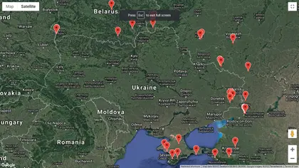
A group of Ukrainian information technology specialists has launched an interactive system to automatically monitor the movement and presence of Russian military formations in and around Ukraine’s state borders.
Going by the Twitter handle of @KordonTech, the group’s founder said the group of volunteers wants to remain anonymous as “some members of our team have relatives in the occupied [Ukrainian] territories and are concerned about their safety.”
JOIN US ON TELEGRAM
Follow our coverage of the war on the @Kyivpost_official.
They first unveiled their interactive maps connected to satellite imagery in a tweet on Feb. 20.
“Our goal is to improve the quality and efficiency of information, which can help the armed forces and reduce the flow of disinformation,” one social media post stated.
Calling itself Kordon [Border], the group said it so far has identified 38 separate locations of Russian military forces using Google’s Earth observation system.
“We are fetching data from the Sentinel-1 satellite and expect to drastically improve the quality of the next imagery by fetching HR SAR data,” the group stated.
According to U.S. intelligence, Russia has deployed nearly 200,000 military personnel and sophisticated heavy weaponry in and around Ukraine for an unexplained purpose and cause.
The U.S. and Britain continue to say that Russia intends to launch a major offensive against Ukraine as part of an ongoing war Moscow has waged against Ukraine unprovoked since 2014, which has claimed more than 14,000 lives.

How the EU Helps Ukraine Reform Police and Justice
You can also highlight the text and press Ctrl + Enter