Ukraine has acquired access to a satellite network which will provide data to help military intelligence target enemy forces.
On June 22, the Serhiy Prytula Charitable Foundation announced a fundraiser among Ukrainians to purchase Byraktar drones. Initially, the fund planned to raise 500 million Hr. to buy three Turkish drones. But within two days, on June 24, total donations reached 600 million Hr., sufficient for four Bayraktars (depending on the specification).
JOIN US ON TELEGRAM
Follow our coverage of the war on the @Kyivpost_official.
However, drone manufacturer Baykar Makina decided to provide three drones to Ukraine for free. The foundation therefore sought other ways to use the collected money to help the army.
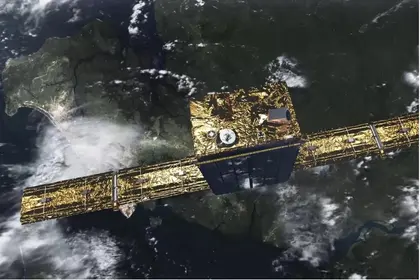
On Aug. 18, Prytula himself announced that he had signed an agreement with Finnish company ICEYE to purchase a high-technology satellite for Ukraine.
On the company’s website, it is reported that the Ukrainian government will have access to “all the capabilities of one of its Synthetic Aperture Radar (SAR) orbiting satellites” for use over the region.
In addition, ICEYE will provide access to its SAR satellite network – the largest single network in the world – which will allow the military forces of Ukraine to receive radar satellite images of critical locations.
In a video message, Prytula stated: “Ukrainians! We bought a satellite! And not just one satellite but access to the database of satellite images of the entire ICEYE network for more than a year. This will allow the Ukrainian intelligence access to data from the company’s 21 satellites.”

Umerov in Seoul – Intel Transfers Agreed, No Weapon Deliveries Mentioned
The ICEYE SAR satellite will help to pinpoint targets for Western-supplied high-precision weapons that Ukraine has received from partner countries.
Usually, the purpose of such satellites is to monitor Earth’s surface and observe weather and climate patterns They send a signal to Earth, then radiation is reflected from the surface, received by an antenna and processed in real-time by the program, which then creates a three-dimensional image of the landscape and ground objects.
Most satellites do not work well at night or on cloudy days. But SAR satellites use a type of radar technology that can see at night through clouds, fog, ash, rain, and even objects, such as camouflage nets or branches.
The importance of satellite data in wartime cannot be overstated – especially those that can provide detailed and high-quality images.
You can also highlight the text and press Ctrl + Enter


